 NERC Data Catalogue Service
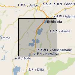
Magnetotelluric and Transient Electromagnetic data from the Main Ethiopian Rift (NERC Grant NE/L013932/1)
This data set includes the original time series collected with broadband and long-period MT instruments during two field seasons in 2016 and 2017 by a team of researchers from the University of Edinburgh, UK and the Institute for Geophysics, Space Science and Astronomy at Addis Ababa university, Ethiopia. For the magnetotelluric stations, processed transfer functions are included in the edi file format. The time series data is provided both in the original raw data format and an ascii version. We provide information on the locations and the processing and include the necessary instrument response functions and metadata to reproduce our results from the raw data. For the TEM recordings, site coordinates and raw data are included in the original format.
Simple
- Date (Creation)
- 2020-08-10
- Maintenance and update frequency
- notApplicable notApplicable
- GEMET - INSPIRE themes, version 1.0
- BGS Thesaurus of Geosciences
-
- Rift valleys
- Rift zone
- Magnetotelluric surveys
- dataCentre
- Keywords
-
- NERC_DDC
- Access constraints
- otherRestrictions Other restrictions
- Other constraints
- licenceOGL
- Use constraints
- otherRestrictions Other restrictions
- Other constraints
- The copyright of materials derived from the British Geological Survey's work is vested in the Natural Environment Research Council [NERC]. No part of this work may be reproduced or transmitted in any form or by any means, or stored in a retrieval system of any nature, without the prior permission of the copyright holder, via the BGS Intellectual Property Rights Manager. Use by customers of information provided by the BGS, is at the customer's own risk. In view of the disparate sources of information at BGS's disposal, including such material donated to BGS, that BGS accepts in good faith as being accurate, the Natural Environment Research Council (NERC) gives no warranty, expressed or implied, as to the quality or accuracy of the information supplied, or to the information's suitability for any use. NERC/BGS accepts no liability whatever in respect of loss, damage, injury or other occurence however caused.
- Other constraints
- Available under the Open Government Licence subject to the following acknowledgement accompanying the reproduced NERC materials "Contains NERC materials ©NERC [year]"
- Metadata language
- EnglishEnglish
- Topic category
-
- Geoscientific information
- Geographic identifier
-
ET
- Date (Revision)
- 2009
- Geographic identifier
-
ETH
- Date (Revision)
- 2009
- Geographic identifier
-
ETHIOPIA [id=692000]
- Date (Creation)
- 1979
- Geographic identifier
-
Main Ethiopian Rift [id=985019]
- Date (Creation)
- 1979
N
S
E
W
))
- Begin date
- 2016-01-25
- End date
- 2017-05-07
Reference System Information
No information provided.
- Distribution format
-
-
Microsoft Excel
()
-
Microsoft Excel
()
- OnLine resource
- Data ( WWW:DOWNLOAD-1.0-http--download )
- OnLine resource
-
Citation Information - Digital Object Identifier (DOI)
(
WWW:LINK-1.0-http--related
)
Huebert, J., Whaler, K. (2020): Magnetotelluric and Transient Electromagnetic data from the Main Ethiopian Rift. British Geological Survey. (Dataset). https://doi.org/10.5285/2fb02ed4-5f50-4c14-aeec-27ee13aafc38
- Hierarchy level
- dataset Dataset
- Other
- dataset
Conformance result
- Date (Publication)
- 2011
- Explanation
- See the referenced specification
- Pass
- No
Conformance result
- Date (Publication)
- 2010-12-08
- Explanation
- See http://eur-lex.europa.eu/LexUriServ/LexUriServ.do?uri=OJ:L:2010:323:0011:0102:EN:PDF
- Pass
- No
- Statement
- Broadband Magnetotelluric (BMT) data were collected with Phoenix MTU5A systems, owned by Dublin Institute for Advanced Studies. Long period data (LMT) were recorded using LEMI-417 also owned by Dublin Institute for Advanced Studies. The processing for the BMT data after Egbert, G. D. (1997). Robust multiple?station magnetotelluric data processing. Geophysical Journal International, 130(2), 475–496. LMT data were processed with Smirnov, M. Y. (2003). Magnetotelluric data processing with a robust statistical procedure having a high breakdown point. Geophysical Journal International, 152(1), 1–7. The TEM data were collected at 15 sites using a Geonics TEM58 RX owned by the NERC Geophysical Equipment Facility in Edinburgh, UK. Originally it was intended to collect data at all MT site locations, but this was not possible due to the political situation during the field campaign in 2016.
- File identifier
- ad245976-93dc-7043-e054-002128a47908 XML
- Metadata language
- EnglishEnglish
- Hierarchy level
- dataset Dataset
- Date stamp
- 2026-05-03
- Metadata standard name
- UK GEMINI
- Metadata standard version
- 2.3
- Dataset URI
- http://data.bgs.ac.uk/id/dataHolding/13607654
Overviews
Spatial extent
N
S
E
W
Provided by

Associated resources
Not available