 NERC Data Catalogue Service
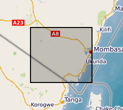
River Water Level Data, Kwale County, Kenya (NERC grant NE/M008894/1)
The dataset contains hourly river water level data for 3 monitoring sites; Mukurumudzi River (3KD06 Shimba Hills & KISCOL Weir) Ramisi River (Eshu Bridge) in Kwale County, Kenya
Simple
- Date (Creation)
- 2019-08-07
Principal investigator
University of Oxford
-
Dr R A Hope
(
School of Geography and the Environment
)
Oxford
,
OX1 3QY
,
Point of contact
University of Oxford
-
Nancy Gladstone
(
Smith School of Enterprise and the Environment
)
Oxford
,
OX1 3QY
,
- Maintenance and update frequency
- notApplicable notApplicable
- GEMET - INSPIRE themes, version 1.0
- BGS Thesaurus of Geosciences
-
- Groundwater
- Citable Data
- Ground water level
- Water quality
- NGDC Deposited Data
- dataCentre
- Keywords
-
- NERC_DDC
- Access constraints
- otherRestrictions Other restrictions
- Other constraints
- no limitations
- Other constraints
- The dataset is made freely available for access, e.g. via the Internet. Either no third party data / information is contained in the dataset or BGS has secured written permission from the owner(s) of any third party data / information contained in the dataset to make the dataset freely accessible.
- Use constraints
- otherRestrictions Other restrictions
- Other constraints
- The copyright of materials derived from the British Geological Survey's work is vested in the Natural Environment Research Council [NERC]. No part of this work may be reproduced or transmitted in any form or by any means, or stored in a retrieval system of any nature, without the prior permission of the copyright holder, via the BGS Intellectual Property Rights Manager. Use by customers of information provided by the BGS, is at the customer's own risk. In view of the disparate sources of information at BGS's disposal, including such material donated to BGS, that BGS accepts in good faith as being accurate, the Natural Environment Research Council (NERC) gives no warranty, expressed or implied, as to the quality or accuracy of the information supplied, or to the information's suitability for any use. NERC/BGS accepts no liability whatever in respect of loss, damage, injury or other occurence however caused.
- Other constraints
- Available under the Open Government Licence subject to the following acknowledgement accompanying the reproduced NERC materials "Contains NERC materials ©NERC [year]"
- Metadata language
- EnglishEnglish
- Topic category
-
- Geoscientific information
- Geographic identifier
-
KE
- Date (Revision)
- 2009
- Geographic identifier
-
KEN
- Date (Revision)
- 2009
- Geographic identifier
-
KENYA [id=687000]
- Date (Creation)
- 1979
N
S
E
W
))
- Begin date
- 2016-01-23
- End date
- 2018-12-26
- Unique resource identifier
- Arc 1960 / UTM zone 37S (EPSG::21037)
- Distribution format
-
-
Microsoft Excel
()
-
Microsoft Excel
()
- OnLine resource
- Data ( WWW:DOWNLOAD-1.0-http--download )
- OnLine resource
-
Citation Information - Digital Object Identifier (DOI)
(
WWW:LINK-1.0-http--related
)
Thomas, M., Wara, C. (2019): River Water Level Data, Kwale County, Kenya. British Geological Survey. (Dataset). https://dx.doi.org/10.5285/b124c503-f900-41fd-b22f-4c0a22ca90bf
- Hierarchy level
- dataset Dataset
- Other
- dataset
Conformance result
- Date (Publication)
- 2011
- Explanation
- See the referenced specification
- Pass
- No
Conformance result
- Date (Publication)
- 2010-12-08
- Explanation
- See http://eur-lex.europa.eu/LexUriServ/LexUriServ.do?uri=OJ:L:2010:323:0011:0102:EN:PDF
- Pass
- No
- Statement
- The collection of the data was done fortnightly using a Heron Dipper instrument (Water Level), and a Hanna meter instrument for groundwater and surface water quality (pH, EC and Temperature). Before the Hanna meter was used for water quality testing, the instrument was first calibrated for pH using pH7 (HI 7007) and pH4 (HI7004) solutions and for Electrical Conductivity, EC using conductivity solution (HI70031) to ensure accuracy of the measured parameters. To measure groundwater level, a Heron Dipper was lowered into the well and the groundwater level (table) measured with reference to ground level.
- File identifier
- 9037d094-6b60-1d12-e054-002128a47908 XML
- Metadata language
- EnglishEnglish
- Hierarchy level
- dataset Dataset
- Date stamp
- 2025-12-11
- Metadata standard name
- UK GEMINI
- Metadata standard version
- 2.3
Point of contact
British Geological Survey
Environmental Science Centre,Keyworth
,
NOTTINGHAM
,
NOTTINGHAMSHIRE
,
NG12 5GG
,
United Kingdom
+44 115 936 3100
- Dataset URI
- http://data.bgs.ac.uk/id/dataHolding/13607495
Overviews
Spatial extent
N
S
E
W
Provided by

Associated resources
Not available