 NERC Data Catalogue Service
HadISDH land: gridded global monthly land surface humidity data version 4.2.0.2019f
This is the 4.2.0.2019f version of the HadISDH (Integrated Surface Database Humidity) land data. These data are provided by the Met Office Hadley Centre. This version spans 1/1/1973 to 31/12/2019.
The data are monthly gridded (5 degree by 5 degree) fields. Products are available for temperature and six humidity variables: specific humidity (q), relative humidity (RH), dew point temperature (Td), wet bulb temperature (Tw), vapour pressure (e), dew point depression (DPD). Data are provided in either NetCDF or ASCII format.
This version extends the 4.1.0.2018f version to the end of 2019 and constitutes a minor update to HadISDH due to changing some of the code base from IDL to Python 3 and detecting and fixing various bugs in the process. These have led to small changes in regional and global average values and coverage. All other processing steps for HadISDH remain identical. Users are advised to read the update document in the Docs section for full details.
As in previous years, the annual scrape of NOAA’s Integrated Surface Dataset for HadISD.3.1.0.2019f, which is the basis of HadISDH.land, has pulled through some historical changes to stations. This, and the additional year of data, results in small changes to station selection. There has been an issue with data for April 2015 whereby it is missing for most of the globe. This will hopefully be resolved by next year’s update. The homogeneity adjustments differ slightly due to sensitivity to the addition and loss of stations, historical changes to stations previously included and the additional 12 months of data.
To keep informed about updates, news and announcements follow the HadOBS team on twitter @metofficeHadOBS.
For more detailed information e.g bug fixes, routine updates and other exploratory analysis, see the HadISDH blog: http://hadisdh.blogspot.co.uk/
References:
When using the dataset in a paper please cite the following papers (see Docs for link to the publications) and this dataset (using the "citable as" reference):
Willett, K. M., Dunn, R. J. H., Thorne, P. W., Bell, S., de Podesta, M., Parker, D. E., Jones, P. D., and Williams Jr., C. N.: HadISDH land surface multi-variable humidity and temperature record for climate monitoring, Clim. Past, 10, 1983-2006, doi:10.5194/cp-10-1983-2014, 2014.
Dunn, R. J. H., et al. 2016: Expanding HadISD: quality-controlled, sub-daily station data from 1931, Geoscientific Instrumentation, Methods and Data Systems, 5, 473-491.
Smith, A., N. Lott, and R. Vose, 2011: The Integrated Surface Database: Recent Developments and Partnerships. Bulletin of the American Meteorological Society, 92, 704–708, doi:10.1175/2011BAMS3015.1
We strongly recommend that you read these papers before making use of the data, more detail on the dataset can be found in an earlier publication:
Willett, K. M., Williams Jr., C. N., Dunn, R. J. H., Thorne, P. W., Bell, S., de Podesta, M., Jones, P. D., and Parker D. E., 2013: HadISDH: An updated land surface specific humidity product for climate monitoring. Climate of the Past, 9, 657-677, doi:10.5194/cp-9-657-2013.
Simple
- Date (Publication)
- 2020-06-29T11:40:00
- Date (Creation)
- 2020-06-29T11:40:00
- Identifier
- Centre for Environmental Data Analysis (CEDA) / 3e9f387293294f3b8a850524fcfc0c9c
- Identifier
- doi / 10.5285/3e9f387293294f3b8a850524fcfc0c9c
- Maintenance and update frequency
- notPlanned Not planned
- Update scope
- dataset Dataset
- Keywords
-
- HadISDH
- humidity
- surface
- land
- gridded
- station
- specific humidity
- temperature
- dew point temperature
- wet bulb temperature
- dew point temperature
- vapour pressure
- in-situ
- GEMET - INSPIRE themes, version 1.0
-
- atmospheric conditions
- Access constraints
- otherRestrictions Other restrictions
- Other constraints
- Public data: access to these data is available to both registered and non-registered users.
- Use constraints
- otherRestrictions Other restrictions
- Spatial representation type
- grid Grid
- Metadata language
- EnglishEnglish
- Topic category
-
- Climatology, meteorology, atmosphere
))
- Begin date
- 1973-01-01T00:00:00
- End date
- 2019-12-31T23:59:59
- Unique resource identifier
- WGS 84
- Distribution format
-
-
These data are provided in NetCDF and ASCII formats, descriptors of the file formats are included in Docs.
()
-
These data are provided in NetCDF and ASCII formats, descriptors of the file formats are included in Docs.
()
- OnLine resource
-
CEDA Data Catalogue Page
Detail and access information for the resource
- OnLine resource
-
DOWNLOAD
Download Data
- OnLine resource
-
Integrated surface database reference paper
No further details.
- OnLine resource
-
HadISDH 2013 reference paper
No further details.
- OnLine resource
-
HadISDH 2014 reference paper
No further details.
- OnLine resource
-
Dunn, R. J. H., Willett, K. M., Parker, D. E., and Mitchell, L.: Expanding HadISD: quality-controlled, sub-daily station data from 1931, Geosci. Instrum. Method. Data Syst., 5, 473-491, doi:10.5194/gi-5-473-2016, 2016.
No further details.
- OnLine resource
-
HadISDH Homepage
No further details.
- OnLine resource
-
Met Office HadOBS twitter feed
No further details.
- OnLine resource
-
HadISDH blog
No further details.
- OnLine resource
-
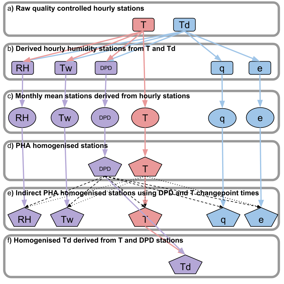
HadISDH process diagram
No further details.
- OnLine resource
-
HadISDH Data Format v2
No further details.
- OnLine resource
-
HadISDH update doc for v4.2.0.2019f
No further details.
- Hierarchy level
- dataset Dataset
Conformance result
- Date (Publication)
- 2010-12-08
- Statement
- HadISDH-land is a global land surface (~2 m) humidity dataset and is produced by the Met Office Hadley Centre in collaboration with Maynooth University, NOAA NCEI, NPL and CRU. It is based on the quality controlled sub-daily HadISD from the Met Office Hadley Centre which is in turn based on the ISD dataset from NOAA's NCEI. It is passed to CEDA for archiving and distribution.
- File identifier
- 3e9f387293294f3b8a850524fcfc0c9c XML
- Metadata language
- EnglishEnglish
- Character set
- 8-bit variable size UCS Transfer Format, based on ISO/IEC 10646 UTF8
- Parent identifier
- HadISDH: global surface humidity data 251474c7b09449d8b9e7aeaf1461858f
- Hierarchy level
- dataset Dataset
- Date stamp
- 2026-05-06T02:21:24
- Metadata standard name
- UK GEMINI
- Metadata standard version
- 2.3
Overviews
Spatial extent
Provided by
